No Products in the Cart
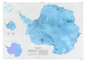
Description: Use this map of the entire Antarctica continent from a mosaic of satellite images to teach and learn about the physical geography of the continent. Survey Date: 1991 Print Date: 1991 Height In Inches: 42.000 Boundary Type: Quadrangle Two Sided: No Pieces: 1 Languages: English Product Number: 28468 Series: I-2284 Scale: 1:5,000,000 Alternate ID: GI2284T ISBN: 978-0-607-79453-3
 As Seen On TV