No Products in the Cart
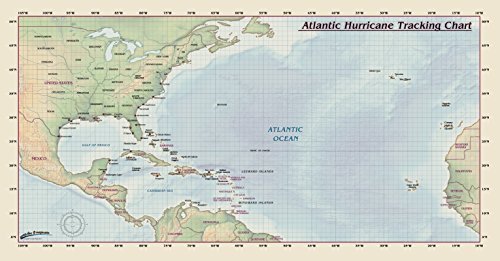
Atlantic Hurricane Tracking Chart by Compart Maps Introducing Compart Maps Atlantic Hurricane Tracking Chart. Beautifully illustrated with subtle earth tone hues, the detail is highly legible and clearly defined. Now you can track the path of any Atlantic Hurricane from West Africa to any North Atlantic Coastline in the Americas This Atlantic Hurricane Tracking Chart features: Physical/Land and Ocean Terrain Latitude/Longitude Lines for GPS tracking Country Names and Boundaries Major Islands Major Cities Major Water Bodies
 As Seen On TV